


Typhoon Wipha Strengthens into Severe Tropical Storm, Set to Make Landfall Along the Coastline from Shenzhen to Wenchang
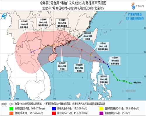
Typhoon Wipha, the sixth typhoon of the year, has intensified into a severe tropical storm. It is expected to make landfall along the southeastern coast of China between Shenzhen in Guangdong Province and Wenchang in Hainan Province, potentially reaching typhoon strength upon landfall.
Before reaching the mainland, Wipha is forecasted to pass south of Hong Kong. The Hong Kong Observatory has issued the Strong Wind Signal No. 3 this afternoon and may upgrade it to Signal No. 8 early tomorrow morning. Strong winds, heavy rain, and rough seas are expected as the storm approaches, and Hong Kong has entered a state of high alert. Ferry services have been partially suspended, and kindergartens and some other educational institutions have suspended classes starting today.
Typhoon Wipha is expected to make landfall tomorrow along the coastal areas from central Guangdong to eastern Hainan. Both Guangdong and Hainan provinces have issued a yellow alert in response. Some ferry services across Guangdong’s coastal waters have been suspended, and railway services are being adjusted with speed restrictions and partial suspensions in place to mitigate potential flooding risks.
Thailand may also be affected by the remnants of Wipha. The Thai Meteorological Department has forecasted heavy rainfall in the northern and northeastern regions from today through next Tuesday, which could lead to localized flooding or river overflows. Authorities are urging residents in those areas to remain on high alert.